Back in 1981, in the dust of the big bust that swept through downtown, leaving an empty 25 million square feet of shiny new office space in its wake, a group of Calgary engineers embarked on a project so out of this world that it would eventually put the city on a new high-tech map.
But the story starts a few months before the bust. In August 1980, Gerard Lachapelle, an engineer with a dimpled chin and a bright Quebecois accent that hadn’t dimmed during four years of postgraduate study in Europe, arrived in Calgary to join Shell Canada. He worked with a small team doing a type of surveying work that used then-modern techniques involving a network of satellites known as the Global Positioning System (GPS). GPS was very much in its infancy – only a handful of satellites were in geostationary orbit, nowhere near the constellation of 27 satellites that exists today and provides a precise, continuous system.
“I remember our first piece of equipment that we were working with to learn the system. It weighed 500 kilos,” says Lachapelle. “Thirty-five years later, 500 kilos has shrunk into a chip inside this,” he says, picking up his iPhone, “which is more powerful than the initial receiver. That chip is about the size of half a thumbnail and that chip can do all the GPS stuff. This is how much it has progressed.”
That progress was unimaginable to the handful of engineers working on GPS in downtown Calgary in 1980. But even then, they knew that the expensive, clunky technology could one day play a role in high-precision areas of oil and gas development where every centimetre counts. That’s what Lachapelle and his colleagues were striving for in October 1980 when the National Energy Program was announced (a federal revenue-sharing initiative enacted by the Trudeau Liberals that many Albertans decried for siphoning hard-earned profits out of the province). They were still working on GPS when the industry took a subsequent blow in 1981 as the global price of oil plummeted.
Over the following year, as unemployment in the province surged and newspaper classified ads began listing homes still filled with furniture for sale at bargain prices, Shell dropped its plan for in-house GPS development. Lachapelle and about 10 colleagues borrowed money to buy the assets from Shell and formed their own company, Nortech Surveys. Their goal was to provide navigational and positioning services using GPS to the oil-and-gas industry. Soon after, they created Norstar Instruments Division to develop GPS software.

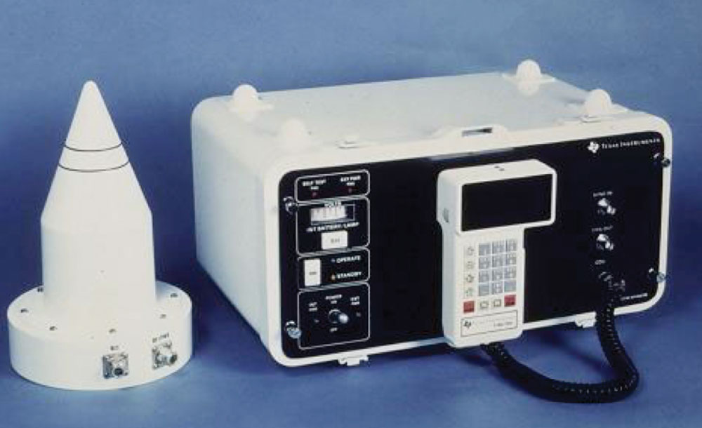
A T14100 GPS receiver developed and built by Texas Instruments in the early 1980s, the first field-deployable GPS receiver on the market. Calgary-based Nortech Surveys ordered the first four commercial units produced in 1981 and used them to successfully conduct surveys around the world for the ocean-exploration and energy industries until the late 1980s.
Elizabeth Cannon, then an undergraduate student in engineering at the University of Calgary, joined Nortech as a summer student in 1983 – the only female engineer among the company’s 50 or so employees. Nobody outside the company, she says, understood what she meant when she said she worked in GPS. (The technology did make headlines that fall when, after Korean Air Lines Flight 007 was shot down for wandering into Soviet airspace, U.S. President Ronald Reagan announced plans to open up for civilian use the GPS system that the Department of Defense was working on.)
That summer, Cannon, who has been president of the University of Calgary since 2010, recalls Nortech’s offices were filled with desks without computers. The bulk of their work was carried out in a large computer lab with multiple terminals where engineers worked collaboratively on computer programming and data processing to develop a GPS receiver.
“At that time, seeing how heavy the equipment was, and how expensive it was, you couldn’t have imagined that one day it’d be small enough to fit into your watch and it would be ubiquitous across society,” says Cannon. “It was kind of exciting to feel that you were part of something that was going to be revolutionary. You knew it was going to be important and you wanted to be part of it.” Following her summer at Nortech, Cannon returned to the University of Calgary to pursue graduate studies eventually receiveing a Ph.D. in geomatics engineering, the discipline of gathering, storing, processing and delivering information related to location.
In 1986, when the space shuttle Challenger exploded, killing everyone on board, it slowed the development of the modern GPS satellite fleet. The GPS satellites had been designed to be launched by space shuttle as they did not fit onto conventional rockets for launch from the ground. For the following three years, no satellites were launched until the U.S. government acquired Delta II, a rocket designed by McDonnell Douglas, to get satellites into orbit.
The delays in the GPS satellite launch forced Nortech to sell its Norstar division to NovAtel in 1988. NovAtel, a public-private joint-venture telecom company formed during Peter Lougheed’s tenure as premier of Alberta, had been founded as part of the Alberta government’s plan to diversify the province’s economy. The hope was that it would help insulate the economy against future drops in oil prices.

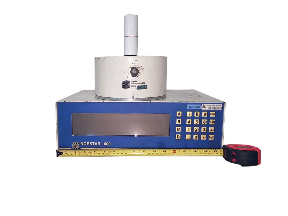
The Norstar1000 unit developed by the Norstar Divison of Nortech Surveys between 1985 and 1988 in partnership with two American companies was one of the most advanced commercial receivers on the market. The technology was transferred to NovAtel in 1989.
NovAtel came to be known as the high-flying star of the 1980s that then flopped dismally – “a stunning failure,” according to the Globe and Mail – costing taxpayers more than $600 million. But after NovAtel divested its non-GPS communication businesses in the 1990s, the remnant was a profitable company focused on GPS chipsets, the guts of the system. NovAtel, now a private company that still employs 350 people from its headquarters in the city’s northeast, has gone on to become one of the world’s prime manufacturers of high-precision global navigation satellite system (GNSS) components and systems. (Since the U.S. developed GPS, other regions in the world followed suit, building satellite navigation systems of their own. A global system, GNSS, has been built up comprised of all satellite navigation systems in the world, including GPS, the Russian GLONASS, the European Union’s Galileo and China’s Beidou.)
What started as a far-fetched idea by a group of former Shell engineers in the 1980s has since become a launch pad for a spate of start-ups in geomatics in the city, giving Calgary and the surrounding area one of highest concentration of companies in this industry in the country. As NovAtel’s GPS experience grew, so did the University of Calgary’s geomatics department, where both Cannon and Lachapelle (who eventually married after meeting at Nortech) have worked since the late 1980s.
In the 38 years since the department was established, more than 250 masters and Ph.D. students have completed their studies in positioning and navigation work, with an estimated half staying to work in Alberta. Professors have been poached by powerhouse tech companies such as Apple. Numerous patents have come out of research in the department – Lachapelle and his research team alone have around 10 to their credit. One spin-off company from the U of C’s geomatics department, Trusted Positioning Inc., created a new technology for cellphones that allows navigation indoors -“a holy grail of GPS,” one industry watcher said. The company was acquired by Invensense in 2014 for US $36 million.
“You have this very nice synergy in the city, where Calgary became a bit of a mecca of GPS development, talent development, research and application development,” says Cannon. “When people talk about where are things happening in the world in GPS, Calgary would be one of those few communities that people would point to.”
Calgary’s start-up tech community got a further boost from another unlikely source – the collapse of Canadian tech darling and telecom titan Nortel Networks in the early 2000s. The telecommunications and data-networking equipment manufacturer, which once operated six Calgary-area facilities and was valued at nearly $300 billion, laid off tens of thousands of people worldwide, eventually letting go of every one of the more than 3,000 Calgarians employed by the company.
Peter Garrett, president of Innovate Calgary, the University of Calgary’s business incubator and accelerator, worked at Nortel from 1980 until 2001. “Most fundamentally, what Nortel and NovAtel did was build a critical mass of people with talent in the digital and wireless sectors – hardware and software developers, project managers, people with the expertise to operate businesses in this space. When NovAtel, and subsequently Nortel, disappeared, those people blew to the wind and, I don’t think it’s too much of an exaggeration [to say], ended up virtually everywhere in the tech sector in Calgary.”
Last June, more than 60 companies from across Canada met at the Calgary Telus Convention Centre for Tecnovate, a tradeshow featuring the latest in geospatial technology (that is, technology of, or relating to, the relative position of things on the earth’s surface). Tecnovate is hosted by Tecterra, a Calgary group that specializes in supporting small- and mid-sized Canadian businesses in the geospatial industry. Tecterra has worked with more than 160 geospatial companies in Alberta, including 69 start-ups.
Among the conference highlights was a station at which attendees could attempt to ride a “backward” bike, where the front wheel turns counter to the direction you turn the handlebars – a deliberately frustrating exercise designed to reinforce the idea that innovation can be uncomfortable and difficult. Tradeshow exhibitors included companies specializing in subjects such as location intelligence, worker safety, energy efficiency, mapping and virtual reality. A few of the local start-ups on site included Decisive Farming (technology that provides farmers with financial and agronomic data, including seed and fertilization recommendations based on their land), LocalIntel (an online site that provides community-by-community demographic and economic information to guide companies looking to invest), and Blackline Safety (technology that provides wireless monitoring of lone workers to track their safety in the field).

An attendee of last June’s Tecnovate tradeshow attempting to ride a bike with handlebars that turn the wheel in the opposite direction than expected.
Tecterra CEO Jonathan Neufeld says Calgary is developing a reputation as a centre for geospatial innovation on both national and global levels. The province is home to 40 per cent of the country’s geospatial firms, largely a result of the U of C and the resource companies that have been willing adopters of the new technology.
Neufeld graduated from the University of Calgary’s geomatics program in 2003, well after NovAtel and Nortel’s prime. Looking back, he acknowledges that those companies were instrumental in sparking an industry here. “They were the big giants that paved the way for everybody else, the ones who established an industry presence here in Calgary,” he says.
If you want evidence of a start-up success with roots in NovAtel and Nortel, drive northwest on Crowchild Trail, past the university and the outer suburbs and the Bearspaw Country Club and down the 3.5-kilometre hill with its seven-per cent grade (infamous among road cyclists) into the town of Cochrane. With a population of just over 26,000 in the 2017 municipal census, there is a strong chance that more sport technology is built per capita here than anywhere else on the planet. The town is home to Garmin Cochrane and 4iiiis – both makers of wearable sport-technology. And both companies also have ties to the husband-and-wife engineering team of Kip Fyfe and Victoria Brilz.
Fyfe and Brilz moved to Calgary in 1987; he took a job with NovAtel, she with IBM. Fyfe’s position involved writing software for cellphones and, while at NovAtel, he created an unusual patent related to having multiple protocols for a single cellphone. While this was a rarity at the time, it has since become commonplace, modern cellphones having 10 to 20 protocols. One company decided to fight his patent. It failed. “So, I became an expert witness and it’s there I learned the power of a patent,” Fyfe says.
In the late 1990s, two things happened that were gamechangers for Fyfe and Brilz. First, Kip’s brother Ken Fyfe, a mechanical-engineering professor at the University of Alberta, came up with a groundbreaking technology that allowed runners to know how fast and far they were running in real time with a little pod that could be put into their shoes. Around the same time, the couple was in a serious car accident that involved hitting a gravel truck. The experience gave them a new outlook on life and inspired them to embark on their own tech start-up journey. As Kip Fyfe says: “We figured the rest of our life is for free.”
Working from the couple’s new home in Cochrane, it took two tries, but Fyfe and Brilz, along with Ken Fyfe and a fourth co-founder, Jim Rooney, eventually succeeded in launching Dynastream Innovations Inc., developing a foot pod and a wireless technology (ANT protocol) that’s used in most wireless cycling and running technologies for athletes. Since the company formed just as Nortel went into its tailspin and NovAtel laid off employees, Dynastream was able to pick up people with technical know-how. Soon after Dynastream finalized its first contract with Nike, the technology exploded into mass consciousness. In 2006, Garmin acquired Dynastream for approximately $46 million (in cash) and still runs the company out of Cochrane.
Since then, Kip Fyfe and Victoria Brilz have started another company, 4iiii Innovations, just 1.3-km down the road from Garmin Cochrane, producing wireless technologies that give athletes real-time feedback on performance. Among the users of 4iiii products are a past holder of the America’s Cup and Tour de France cyclists.
The environment now for technology start-ups in Calgary is very different than it was three decades ago, says Fyfe, who serves on a number of boards for start-up companies and the organizations that support them. “The information they have versus the information I had access to are a hundred-fold different. There are a lot more people doing start-ups. We were the only clowns at the time who were trying to do that.”
Garrett, of Innovate Calgary, says that for all the successes, there is still a long way to go for Calgary’s innovation community. The field will always be subject to the cycles of commodity-pricing waves: when oil and gas is at the top of the wave, more people will be lured into the energy sector. When it’s down, people migrate to tech. “Tech is very complementary to the oil and gas industry in that regard and helps to stabilize the overall economy,” says Garrett.
That cyclical nature has advantages and disadvantages for Calgary’s geomatics industry. After all, the industry got its start when Lachapelle and his team of young colleagues were let loose from Shell during a downturn and formed their own company. They then grew it during an upturn in the local economy. In the 40 years since, Calgary’s geomatics industry hasn’t always been on a steady incline. Companies have come and gone; more are likely to come and go. But in the meantime, the city has slowly built up a critical mass of talent. Today, it’s more than a few scattershot companies working in isolation. Instead, it’s a real ecosystem of start-ups that have put Calgary on the geomatics map.
3 pieces of technology created by Cochrane companies

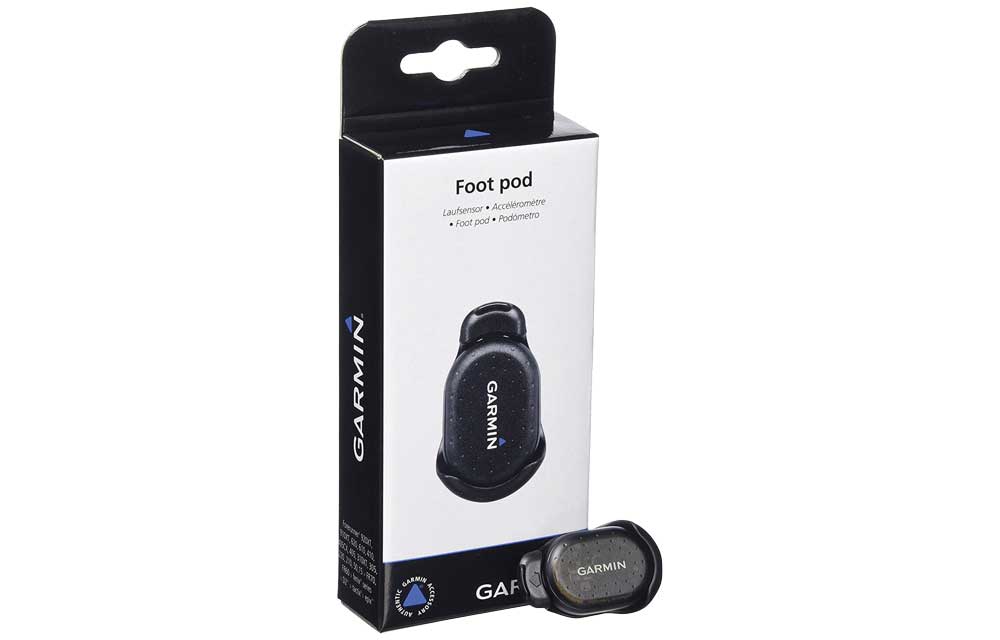
Foot pod, developed by Cochrane-based Dynastream Innovations (now owned by Garmin), lets runners know how far and fast they’re running in real time.

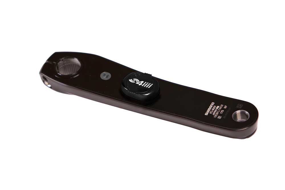
Waterproof powermeters created by Cochrane-based technology company 4iiiis are used by the Oracle Team USA sailing crew.

The Bora Hansgrohe and Quick Step Floors procycling team, which includes world-champion rider Peter Sagan, also uses powermeters by 4iiiis.

